The current availability of powerful computing tools, combined with the acquisition of high spatial and temporal resolution images generated by remote sensors, allows the monitoring of the trophic state in reservoirs by evaluating the reflectance signals collected by the sensors on board the satellites.
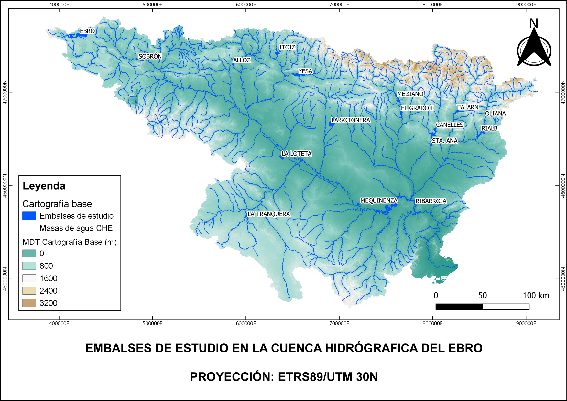
Based on this technology, the Confederación Hidrográfica del Ebro, through the Subdirección General de Protección de las Aguas y Gestión de Riesgos, is carrying out the monitoring of several reservoirs in the Ebro river basin.
In collaboration with OFITECO and the University of Valencia, LWD has conducted a study on the trophic status of 17 Ebro reservoirs for the year 2020.
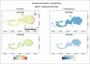
The aim of this work was to develop a methodology that allows obtaining (almost) real time water quality maps using reservoirs as a reference for water mass. To do this, the physicochemical data provided by the Water Quality Area have been combined with the images generated by remote sensors.
The parameters investigated have optical properties and thus, can be measured by the satellite. The equations have been calibrated to estimate the concentration of chlorophyll-a, suspended solids, transparency, turbidity, phycocyanin, and chromophoric (or colored) dissolved organic matter (CDOM).
Calibrated equations and quality maps were developed for each reservoir. In addition, the trophic status of each body of water was estimated with both, the data acquired through the Sentinel-2 and Landsat-8 satellites, and the ones in the field campaigns.
The final report with complete with results was delivered in September 2021